|
| at: |
Kisatchie National Forest - Winn/Catahoula Districts |
Data from USFS GIS
 show on map
 animate
Trail users:


Elevation Profile
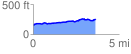
 3.634305 mi
 211.71 ft
 120.55 ft
 91.16 ft
 1.10 %
GPX Downloads: Track Route
![]()
|
| at: |
Kisatchie National Forest - Winn/Catahoula Districts |
show on map
animate
3.634305 mi
211.71 ft
120.55 ft
91.16 ft
1.10 %