| at: |
Kisatchie National Forest - Winn/Catahoula Districts |
Data from USFS GIS
 show on map
 animate
Trail users:


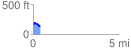
Elevation Profile
 0.445437 mi
 29.33 ft
 66.21 ft
 -36.89 ft
 2.82 %
GPX Downloads: Track Route
![]()
| at: |
Kisatchie National Forest - Winn/Catahoula Districts |
show on map
animate
0.445437 mi
29.33 ft
66.21 ft
-36.89 ft
2.82 %