| at: |
Kisatchie National Forest - Winn/Catahoula Districts |
Data from USFS GIS
 show on map
 animate
Trail users:


Elevation Profile
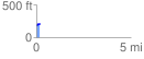
 0.184250 mi
 38.73 ft
 6.07 ft
 32.66 ft
 3.98 %
GPX Downloads: Track Route
![]()
| at: |
Kisatchie National Forest - Winn/Catahoula Districts |
show on map
animate
0.184250 mi
38.73 ft
6.07 ft
32.66 ft
3.98 %