| at: |
Swallow Creek WMA |
Data from David Muse
 show on map
 animate
Trail users:


Elevation Profile
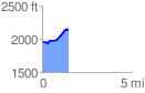
 1.476232 mi
 239.18 ft
 55.46 ft
 183.72 ft
 3.07 %
GPX Downloads: Track Route
![]()
| at: |
Swallow Creek WMA |
show on map
animate
1.476232 mi
239.18 ft
55.46 ft
183.72 ft
3.07 %