|
| at: |
Coleman River Scenic Area |
Data from David Muse
 show on map
 animate
Trail users:


Elevation Profile
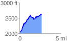
 2.671797 mi
 908.78 ft
 312.19 ft
 596.60 ft
 6.44 %
GPX Downloads: Track Route
![]()
|
| at: |
Coleman River Scenic Area |
show on map
animate
2.671797 mi
908.78 ft
312.19 ft
596.60 ft
6.44 %