| at: |
Kisatchie National Forest - Winn/Catahoula Districts |
Data from USFS GIS
 show on map
 animate
Trail users:


Elevation Profile
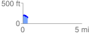
 0.434893 mi
 31.54 ft
 92.73 ft
 -61.19 ft
 4.04 %
GPX Downloads: Track Route
![]()
| at: |
Kisatchie National Forest - Winn/Catahoula Districts |
show on map
animate
0.434893 mi
31.54 ft
92.73 ft
-61.19 ft
4.04 %