| at: |
Fort Mountain State Park Area Windy Gap |
Data from David Muse
 show on map
 animate
Trail users:


Elevation Profile
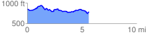
 5.706473 mi
 401.15 ft
 463.24 ft
 -62.09 ft
 1.54 %
GPX Downloads: Track Route
![]()
| at: |
Fort Mountain State Park Area Windy Gap |
show on map
animate
5.706473 mi
401.15 ft
463.24 ft
-62.09 ft
1.54 %