| at: |
Kisatchie National Forest - Kisatchie District |
Data from USFS GIS
 show on map
 animate
Trail users:


Elevation Profile
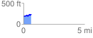
 0.626413 mi
 82.29 ft
 56.49 ft
 25.81 ft
 2.49 %
GPX Downloads: Track Route
![]()
| at: |
Kisatchie National Forest - Kisatchie District |
show on map
animate
0.626413 mi
82.29 ft
56.49 ft
25.81 ft
2.49 %