| at: |
Fort Mountain State Park Area |
Data from David Muse
 show on map
 animate
Trail users:


Elevation Profile
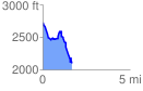
 1.657404 mi
 244.19 ft
 871.73 ft
 -627.54 ft
 9.96 %
GPX Downloads: Track Route
![]()
| at: |
Fort Mountain State Park Area |
show on map
animate
1.657404 mi
244.19 ft
871.73 ft
-627.54 ft
9.96 %