|
| at: |
Kisatchie National Forest - Kisatchie District |
Data from USFS GIS
 show on map
 animate
Trail users:


Elevation Profile
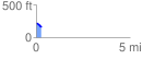
 0.298774 mi
 0.18 ft
 69.68 ft
 -69.50 ft
 4.42 %
GPX Downloads: Track Route
![]()
|
| at: |
Kisatchie National Forest - Kisatchie District |
show on map
animate
0.298774 mi
0.18 ft
69.68 ft
-69.50 ft
4.42 %