| at: |
Kisatchie National Forest - Kisatchie District |
Data from USFS GIS
 show on map
 animate
Trail users:


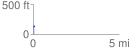
Elevation Profile
 0.062072 mi
 17.08 ft
 1.10 ft
 15.98 ft
 5.21 %
GPX Downloads: Track Route
![]()
| at: |
Kisatchie National Forest - Kisatchie District |
show on map
animate
0.062072 mi
17.08 ft
1.10 ft
15.98 ft
5.21 %