| at: |
Kisatchie National Forest - Kisatchie District |
Data from USFS GIS
 show on map
 animate
Trail users:


Elevation Profile
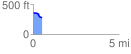
 0.512278 mi
 5.31 ft
 83.60 ft
 -78.30 ft
 3.09 %
GPX Downloads: Track Route
![]()
| at: |
Kisatchie National Forest - Kisatchie District |
show on map
animate
0.512278 mi
5.31 ft
83.60 ft
-78.30 ft
3.09 %