| at: |
Stonewall Falls Area |
Data from David Muse
 show on map
 animate
Trail users:


Elevation Profile
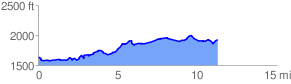
 11.338771 mi
 1058.27 ft
 750.31 ft
 307.96 ft
 1.77 %
GPX Downloads: Track Route
![]()
| at: |
Stonewall Falls Area |
show on map
animate
11.338771 mi
1058.27 ft
750.31 ft
307.96 ft
1.77 %