| at: |
Stonewall Falls Area |
Data from David Muse
 show on map
 animate
Trail users:


Elevation Profile
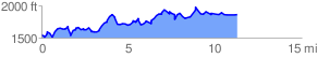
 11.444044 mi
 1919.72 ft
 1613.25 ft
 306.47 ft
 3.18 %
GPX Downloads: Track Route
![]()
| at: |
Stonewall Falls Area |
show on map
animate
11.444044 mi
1919.72 ft
1613.25 ft
306.47 ft
3.18 %