| at: |
Kisatchie National Forest - Kisatchie District |
Data from USFS GIS
 show on map
 animate
Trail users:


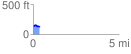
Elevation Profile
 0.364437 mi
 30.90 ft
 32.63 ft
 -1.73 ft
 1.70 %
GPX Downloads: Track Route
![]()
| at: |
Kisatchie National Forest - Kisatchie District |
show on map
animate
0.364437 mi
30.90 ft
32.63 ft
-1.73 ft
1.70 %