| at: |
Kisatchie National Forest - Kisatchie District |
Data from USFS GIS
 show on map
 animate
Trail users:


Elevation Profile
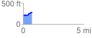
 0.742765 mi
 87.96 ft
 12.08 ft
 75.88 ft
 2.24 %
GPX Downloads: Track Route
![]()
| at: |
Kisatchie National Forest - Kisatchie District |
show on map
animate
0.742765 mi
87.96 ft
12.08 ft
75.88 ft
2.24 %