| at: |
Kisatchie National Forest - Kisatchie District |
Data from USFS GIS
 show on map
 animate
Trail users:


Elevation Profile
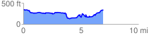
 6.982725 mi
 679.81 ft
 694.30 ft
 -14.49 ft
 1.88 %
GPX Downloads: Track Route
![]()
| at: |
Kisatchie National Forest - Kisatchie District |
show on map
animate
6.982725 mi
679.81 ft
694.30 ft
-14.49 ft
1.88 %