| at: |
Kisatchie National Forest - Calcasieu District - Evangeline Unit |
Data from USFS GIS
 show on map
 animate
Trail users:


Elevation Profile
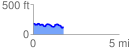
 1.758200 mi
 142.88 ft
 199.21 ft
 -56.33 ft
 2.15 %
GPX Downloads: Track Route
![]()
| at: |
Kisatchie National Forest - Calcasieu District - Evangeline Unit |
show on map
animate
1.758200 mi
142.88 ft
199.21 ft
-56.33 ft
2.15 %