|
| at: |
Kisatchie National Forest - Calcasieu District - Vernon Unit |
Data from USFS GIS
 show on map
 animate
Trail users:


Elevation Profile
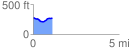
 1.134697 mi
 72.55 ft
 78.71 ft
 -6.15 ft
 1.31 %
GPX Downloads: Track Route
![]()
|
| at: |
Kisatchie National Forest - Calcasieu District - Vernon Unit |
show on map
animate
1.134697 mi
72.55 ft
78.71 ft
-6.15 ft
1.31 %