| at: |
Kisatchie National Forest - Calcasieu District - Vernon Unit |
Data from USFS GIS
 show on map
 animate
Trail users:


Elevation Profile
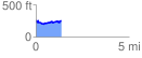
 1.373700 mi
 133.34 ft
 130.37 ft
 2.97 ft
 1.84 %
GPX Downloads: Track Route
![]()
| at: |
Kisatchie National Forest - Calcasieu District - Vernon Unit |
show on map
animate
1.373700 mi
133.34 ft
130.37 ft
2.97 ft
1.84 %