|
| at: |
Sumter National Forest - Enoree District |
Data from USFS GIS
 show on map
 animate
Trail users:


Elevation Profile
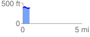
 0.585286 mi
 53.20 ft
 44.64 ft
 8.56 ft
 1.72 %
GPX Downloads: Track Route
![]()
|
| at: |
Sumter National Forest - Enoree District |
show on map
animate
0.585286 mi
53.20 ft
44.64 ft
8.56 ft
1.72 %