|
| at: |
Sumter National Forest - Enoree District |
Data from USFS GIS
 show on map
 animate
Trail users:


Elevation Profile
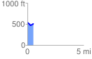
 0.552689 mi
 64.36 ft
 93.69 ft
 -29.33 ft
 3.21 %
GPX Downloads: Track Route
![]()
|
| at: |
Sumter National Forest - Enoree District |
show on map
animate
0.552689 mi
64.36 ft
93.69 ft
-29.33 ft
3.21 %