| at: |
Sumter National Forest - Enoree District |
Data from USFS GIS
 show on map
 animate
Trail users:


Elevation Profile
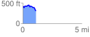
 1.123571 mi
 87.50 ft
 201.73 ft
 -114.23 ft
 3.40 %
GPX Downloads: Track Route
![]()
| at: |
Sumter National Forest - Enoree District |
show on map
animate
1.123571 mi
87.50 ft
201.73 ft
-114.23 ft
3.40 %