|
| at: |
Sumter National Forest - Enoree District |
Data from USFS GIS
 show on map
 animate
Trail users:


Elevation Profile
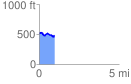
 1.007613 mi
 75.64 ft
 117.10 ft
 -41.46 ft
 2.20 %
GPX Downloads: Track Route
![]()
|
| at: |
Sumter National Forest - Enoree District |
show on map
animate
1.007613 mi
75.64 ft
117.10 ft
-41.46 ft
2.20 %