| at: |
Sumter National Forest - Enoree District |
Data from USFS GIS
 show on map
 animate
Trail users:


Elevation Profile
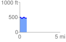
 0.855423 mi
 45.27 ft
 82.02 ft
 -36.75 ft
 1.82 %
GPX Downloads: Track Route
![]()
| at: |
Sumter National Forest - Enoree District |
show on map
animate
0.855423 mi
45.27 ft
82.02 ft
-36.75 ft
1.82 %