| at: |
Sumter National Forest - Enoree District |
Data from USFS GIS
 show on map
 animate
Trail users:


Elevation Profile
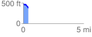
 0.441224 mi
 23.09 ft
 129.99 ft
 -106.90 ft
 5.58 %
GPX Downloads: Track Route
![]()
| at: |
Sumter National Forest - Enoree District |
show on map
animate
0.441224 mi
23.09 ft
129.99 ft
-106.90 ft
5.58 %