| at: |
Sumter National Forest - Enoree District |
Data from USFS GIS
 show on map
 animate
Trail users:


Elevation Profile
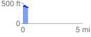
 0.429610 mi
 26.87 ft
 55.36 ft
 -28.49 ft
 2.44 %
GPX Downloads: Track Route
![]()
| at: |
Sumter National Forest - Enoree District |
show on map
animate
0.429610 mi
26.87 ft
55.36 ft
-28.49 ft
2.44 %