|
| at: |
Sumter National Forest - Enoree District |
Data from USFS GIS
 show on map
 animate
Trail users:


Elevation Profile
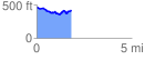
 1.819783 mi
 162.97 ft
 208.69 ft
 -45.73 ft
 2.17 %
GPX Downloads: Track Route
![]()
|
| at: |
Sumter National Forest - Enoree District |
show on map
animate
1.819783 mi
162.97 ft
208.69 ft
-45.73 ft
2.17 %