|
| at: |
Sumter National Forest - Enoree District |
Data from USFS GIS
 show on map
 animate
Trail users:


Elevation Profile
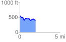
 1.977397 mi
 131.05 ft
 270.54 ft
 -139.49 ft
 2.59 %
GPX Downloads: Track Route
![]()
|
| at: |
Sumter National Forest - Enoree District |
show on map
animate
1.977397 mi
131.05 ft
270.54 ft
-139.49 ft
2.59 %