|
| at: |
Sumter National Forest - Enoree District |
Data from USFS GIS
 show on map
 animate
Trail users:


Elevation Profile
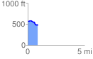
 0.885486 mi
 27.15 ft
 108.78 ft
 -81.62 ft
 2.33 %
GPX Downloads: Track Route
![]()
|
| at: |
Sumter National Forest - Enoree District |
show on map
animate
0.885486 mi
27.15 ft
108.78 ft
-81.62 ft
2.33 %