|
| at: |
Sumter National Forest - Enoree District |
Data from USFS GIS
 show on map
 animate
Trail users:


Elevation Profile
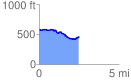
 2.503187 mi
 102.09 ft
 235.22 ft
 -133.13 ft
 1.78 %
GPX Downloads: Track Route
![]()
|
| at: |
Sumter National Forest - Enoree District |
show on map
animate
2.503187 mi
102.09 ft
235.22 ft
-133.13 ft
1.78 %