|
| at: |
Sumter National Forest - Enoree District |
Data from USFS GIS
 show on map
 animate
Trail users:


Elevation Profile
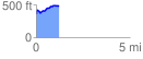
 1.233624 mi
 182.96 ft
 60.87 ft
 122.09 ft
 2.81 %
GPX Downloads: Track Route
![]()
|
| at: |
Sumter National Forest - Enoree District |
show on map
animate
1.233624 mi
182.96 ft
60.87 ft
122.09 ft
2.81 %