|
| at: |
Francis Marion National Forest |
Data from USFS GIS
 show on map
 animate
Trail users:


Elevation Profile
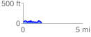
 1.565225 mi
 163.69 ft
 168.39 ft
 -4.70 ft
 2.04 %
GPX Downloads: Track Route
![]()
|
| at: |
Francis Marion National Forest |
show on map
animate
1.565225 mi
163.69 ft
168.39 ft
-4.70 ft
2.04 %