|
| at: |
Francis Marion National Forest |
Data from USFS GIS
 show on map
 animate
Trail users:


Elevation Profile
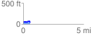
 0.558470 mi
 54.57 ft
 81.75 ft
 -27.18 ft
 2.77 %
GPX Downloads: Track Route
![]()
|
| at: |
Francis Marion National Forest |
show on map
animate
0.558470 mi
54.57 ft
81.75 ft
-27.18 ft
2.77 %