|
| at: |
Francis Marion National Forest |
Data from USFS GIS
 show on map
 animate
Trail users:


Elevation Profile
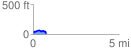
 0.777136 mi
 117.86 ft
 103.80 ft
 14.07 ft
 2.87 %
GPX Downloads: Track Route
![]()
|
| at: |
Francis Marion National Forest |
show on map
animate
0.777136 mi
117.86 ft
103.80 ft
14.07 ft
2.87 %