| at: |
Francis Marion National Forest |
Data from USFS GIS
 show on map
 animate
Trail users:


Elevation Profile
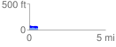
 0.599829 mi
 69.30 ft
 93.11 ft
 -23.81 ft
 2.94 %
GPX Downloads: Track Route
![]()
| at: |
Francis Marion National Forest |
show on map
animate
0.599829 mi
69.30 ft
93.11 ft
-23.81 ft
2.94 %