| at: |
Francis Marion National Forest |
Data from USFS GIS
 show on map
 animate
Trail users:


Elevation Profile
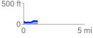
 1.164788 mi
 127.10 ft
 85.31 ft
 41.79 ft
 2.07 %
GPX Downloads: Track Route
![]()
| at: |
Francis Marion National Forest |
show on map
animate
1.164788 mi
127.10 ft
85.31 ft
41.79 ft
2.07 %