|
| at: |
Francis Marion National Forest |
Data from USFS GIS
 show on map
 animate
Trail users:


Elevation Profile
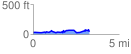
 3.287162 mi
 206.92 ft
 200.00 ft
 6.92 ft
 1.19 %
GPX Downloads: Track Route
![]()
|
| at: |
Francis Marion National Forest |
show on map
animate
3.287162 mi
206.92 ft
200.00 ft
6.92 ft
1.19 %