|
| at: |
Francis Marion National Forest |
Data from USFS GIS
 show on map
 animate
Trail users:


Elevation Profile
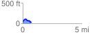
 0.732236 mi
 109.70 ft
 98.49 ft
 11.21 ft
 2.84 %
GPX Downloads: Track Route
![]()
|
| at: |
Francis Marion National Forest |
show on map
animate
0.732236 mi
109.70 ft
98.49 ft
11.21 ft
2.84 %