|
| at: |
Francis Marion National Forest |
Data from USFS GIS
 show on map
 animate
Trail users:


Elevation Profile
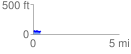
 0.428267 mi
 44.97 ft
 50.11 ft
 -5.14 ft
 2.22 %
GPX Downloads: Track Route
![]()
|
| at: |
Francis Marion National Forest |
show on map
animate
0.428267 mi
44.97 ft
50.11 ft
-5.14 ft
2.22 %