| at: |
Tyler State Park |
Data from 12 Foot Hedgehog (www.12foothedgehog.com)
 show on map
 animate
Trail users:


Elevation Profile
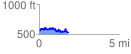
 1.840143 mi
 273.31 ft
 313.34 ft
 -40.02 ft
 3.22 %
GPX Downloads: Track Route
![]()
| at: |
Tyler State Park |
show on map
animate
1.840143 mi
273.31 ft
313.34 ft
-40.02 ft
3.22 %