|
| at: |
Francis Marion National Forest |
Data from USFS GIS
 show on map
 animate
Trail users:


Elevation Profile
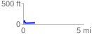
 0.986895 mi
 61.45 ft
 60.76 ft
 0.69 ft
 1.18 %
GPX Downloads: Track Route
![]()
|
| at: |
Francis Marion National Forest |
show on map
animate
0.986895 mi
61.45 ft
60.76 ft
0.69 ft
1.18 %