|
| at: |
Francis Marion National Forest |
Data from USFS GIS
 show on map
 animate
Trail users:


Elevation Profile
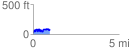
 0.963473 mi
 212.61 ft
 187.02 ft
 25.59 ft
 4.18 %
GPX Downloads: Track Route
![]()
|
| at: |
Francis Marion National Forest |
show on map
animate
0.963473 mi
212.61 ft
187.02 ft
25.59 ft
4.18 %