|
| at: |
Francis Marion National Forest |
Data from USFS GIS
 show on map
 animate
Trail users:


Elevation Profile
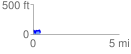
 0.411197 mi
 58.40 ft
 93.10 ft
 -34.69 ft
 4.29 %
GPX Downloads: Track Route
![]()
|
| at: |
Francis Marion National Forest |
show on map
animate
0.411197 mi
58.40 ft
93.10 ft
-34.69 ft
4.29 %