|
| at: |
Francis Marion National Forest |
Data from USFS GIS
 show on map
 animate
Trail users:


Elevation Profile
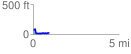
 0.938507 mi
 80.28 ft
 125.25 ft
 -44.96 ft
 2.53 %
GPX Downloads: Track Route
![]()
|
| at: |
Francis Marion National Forest |
show on map
animate
0.938507 mi
80.28 ft
125.25 ft
-44.96 ft
2.53 %