|
| at: |
Francis Marion National Forest |
Data from USFS GIS
 show on map
 animate
Trail users:


Elevation Profile
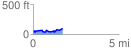
 1.715400 mi
 170.78 ft
 111.38 ft
 59.40 ft
 1.89 %
GPX Downloads: Track Route
![]()
|
| at: |
Francis Marion National Forest |
show on map
animate
1.715400 mi
170.78 ft
111.38 ft
59.40 ft
1.89 %