|
| at: |
Francis Marion National Forest |
Data from USFS GIS
 show on map
 animate
Trail users:


Elevation Profile
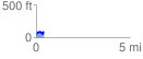
 0.422606 mi
 81.17 ft
 58.33 ft
 22.85 ft
 3.64 %
GPX Downloads: Track Route
![]()
|
| at: |
Francis Marion National Forest |
show on map
animate
0.422606 mi
81.17 ft
58.33 ft
22.85 ft
3.64 %