|
| at: |
Francis Marion National Forest |
Data from USFS GIS
 show on map
 animate
Trail users:


Elevation Profile
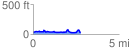
 2.781290 mi
 174.39 ft
 179.66 ft
 -5.26 ft
 1.22 %
GPX Downloads: Track Route
![]()
|
| at: |
Francis Marion National Forest |
show on map
animate
2.781290 mi
174.39 ft
179.66 ft
-5.26 ft
1.22 %