|
| at: |
Francis Marion National Forest |
Data from USFS GIS
 show on map
 animate
Trail users:


Elevation Profile
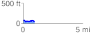
 0.966645 mi
 121.67 ft
 133.85 ft
 -12.18 ft
 2.62 %
GPX Downloads: Track Route
![]()
|
| at: |
Francis Marion National Forest |
show on map
animate
0.966645 mi
121.67 ft
133.85 ft
-12.18 ft
2.62 %