|
| at: |
Francis Marion National Forest |
Data from USFS GIS
 show on map
 animate
Trail users:


Elevation Profile
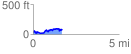
 1.692891 mi
 247.60 ft
 188.03 ft
 59.57 ft
 2.77 %
GPX Downloads: Track Route
![]()
|
| at: |
Francis Marion National Forest |
show on map
animate
1.692891 mi
247.60 ft
188.03 ft
59.57 ft
2.77 %